
Page 34 - Intra Muros October Issue 2025
P. 34
ESTATE NEWS
Would it have been washed away to sea, if not for
the asteroid impact pushing it underground at a
nearly vertical angle?
- These Witwatersrand Super Group rock layers go
underground and tilt up at the Reef – Johannesburg
to Klerksdorp.
- Parts of this gold reef rock layer “poked out of the
ground”, where it was discovered in 1887 on the farm
Langlaagte – now called the City of Johannesburg!
- These tilted, slanting layers containing gold are
where we mine gold for up to 4km.
- Approximately 50 000 to 60 000 tons of gold
have been extracted to date, valued at about
R120 trillion.
- As you all know, the impact of discoveries of gold,
platinum, uranium and other metals became the
backbone of our South African economy, shaping
modern South African history.
The asteroid
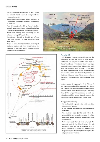
In all the points abovementioned, it’s assumed that
the original structure was round, as in the images I
used above, with the gold embedded in the ridges to
the north and west of the dome. Were these ridges
protected in some way and the ridges to the south
buried or flattened? What happened to the ridges
that were ‘supposed to be’ on the southeast of the
dome? Some people, like Professor Roger Gibson at
the School of Geosciences at Wits University, believe a
glacier from the Ice Age may have eroded away these
ridges.
Another solution is suggested by David P. Howcroft
(see images accross from his dissertation). He indicates
that if one links the positions of the current gold mines,
it seems to form more of an oval shape – measuring
about 330km long on the south-west to north-east
axis and about 165km across. Howcroft proposes that
the asteroid(s) impacted Earth at a shallow angle.
He suggests the following:
- The shallow (5-8 degrees) entry point was about
70km south of Welkom.
- It was not one, but three large fractured metallic
meteorites.
- The fractured reefs (Earth’s crust when the
asteroid(s) hit) on the south-west outer rim of the
entry point are not visible but buried under Karoo
sedimentation.
- To the north-east the ‘old crust’ upturned. The
upturned crust of the old sedimentary (ie. rock
formed not lava, but soil set down by water or
wind) Pretoria Group (layers of Witwatersrand,
Magaliesberg and Waterberg) formed ‘ripples’, the
ridges one sees in this area.
32 | INTRAMUROS OCTOBER 2025